Five Weather-Defining Moments of 2023 for New England
- Tim Dennis
- Dec 30, 2023
- 7 min read
The year 2023 was marked by some intense storms, a handful of tornadoes and a summer of flash flooding. As a matter of fact, the National Weather Service office in Gray, Maine issued a record breaking 38 flash flood warnings for New Hampshire alone in July. This not only shatters the old monthly record of 17, but actually surpasses the most warnings issued in an entire year, which was 36. Again, that was just New Hampshire. Here's a look back at the five most memorable weather events to come through New England this past year:

5. Early-February arctic blast (February 3-4)
What was a very mild (for the most part) January and February in New England was briefly interrupted on the first weekend of February. On February 3rd, a very strong arctic cold front dropped through New England. Temperatures nose-dived throughout the morning on Friday, February 3 and continued to fall through the morning of Saturday, February 4. Temperatures would begin to creep up Saturday afternoon, but wind chills remained below zero through Saturday evening.

Wind chills were truly extreme across New England, with -30 to -60 degree readings common. Wind chills were at their lowest Saturday morning. Throughout Friday night into Saturday morning, some interesting things occurred including trees bursting from the cold, frostquakes, steam devils on Lake Champlain, sea smoke rising over Boston Harbor and even Lake Winnipesaukee as well as a very rare (for New England) ground blizzard in northern Maine.
On top of those phenomena, New England saw several long-standing cold weather records fall or threatened. Boston saw its coldest temperature (-10°) in 66 years, Nantucket saw a rare sub-zero air temperature and Mt. Washington's summit saw a wind chill of -108° when a -47° air temperature was met with 100+mph wind gusts. That -47° low temperature tied the all-time low measured at the Mt. Washington Observatory and came within 3° of New England's all-time coldest temperature (-50°). While there is no official record kept for wind chills, the -108 was the coldest wind chill ever reported in the United States.


Photos: Boston sea smoke (Mark Garfinkel); Mt. Washington on the morning of February 4 (Mt. Washington Observatory); Steam devil on Lake Champlain (NWS Burlington)
New England Storm Center's coverage of this event when it happened:
>How Cold? Wind Chill Reports Across New England (February 4)
>Extreme Arctic Blast Grips New England (February 2)
4. The great nor'easter of 2023 (March 13-15)
In a winter that almost seemed destined not to produce a major snowstorm for much of New England came up big in the closing week of the season. The storm tracked between Cape Cod and the 40/70 benchmark. This led to an initial burst of heavy rain and pounding waves. Over two inches of rain fell across portions of eastern Massachusetts and Rhode Island.
The storm rapidly strengthened as it moved up the New England coast. This allowed the storm to generate its own cold air, allowing heavy rain to flip over to heavy snow across most of New England. Areas that saw snow for the entire duration of the storm were slammed. 24-40+ inch amounts were seen in southern Vermont, southwest New Hampshire, the Berkshires and the Worcester Hills.
Snow totals from March 15, 2023:

The highest snowfall amount was 42.1" in Readsboro, Vermont. This was enough to put this storm in the top five in the New England Snowstorm Hall of Fame. This storm became the fifth snowstorm in New England to make it to the 40 inch mark. The other being the Great White Hurricane (50"), The Great Nor'Easter of 2020 (48") and the Blizzards of 1978 and 2013 (40").
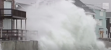

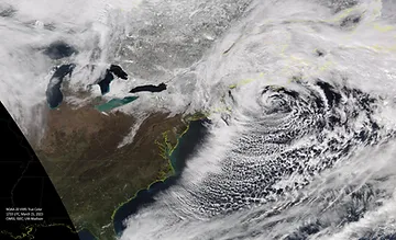


Photos: Massive waves slam Scituate, MA (David Curran LSM); Snow piles up in Stratton, VT (Christ Walker); Satellite image of storm (NOAA); Tree damage in New Hampshire (Unitil)
New England Storm Center's coverage of this event when it happened:
3. December storm (December 17-18)
This list was first created at the beginning of December, before this storm rolled through the region, however, this storm was significant enough to get a last moment entry. This storm formed in the Gulf of Mexico before shooting up and soaking the entire east coast. The storm took an interior track through the northeast, ensuring a soaking rain event. An extreme (for winter) amount of moisture came into New England from a strong southerly low-level jet, allowing intense rainfall rates. This low-level jet also allowed very strong winds.

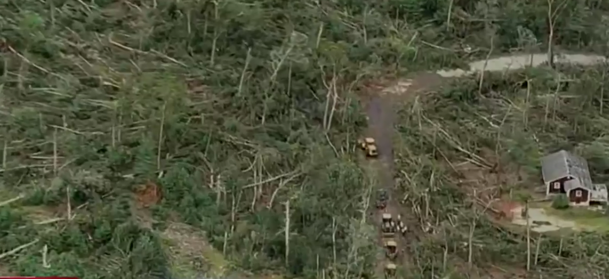
In short, everything came together just right to bring New England a significant storm. The storm intensified as it made its way through New England. Wind gusts as high as 90mph were reported in Maine and Massachusetts. This led to widespread tree damage as well as some structural damage. About 743,000 customers lost power. Coastal flooding was also an issue, especially in Rhode Island.
The biggest impact from this storm proved to be the intense rainfall. Amounts of up to six inches were seen in New Hampshire and Maine with 3-5 inches elsewhere. Over 50 river gauges across New England reached flood stage, with a handful reaching major flood stage. Maine was hit hardest by flooding; the state likely experienced its 2nd worst flooding ever, rivaling the 1987 flood. A dozen rivers saw a top three all-time crest, with three setting new all-time records.


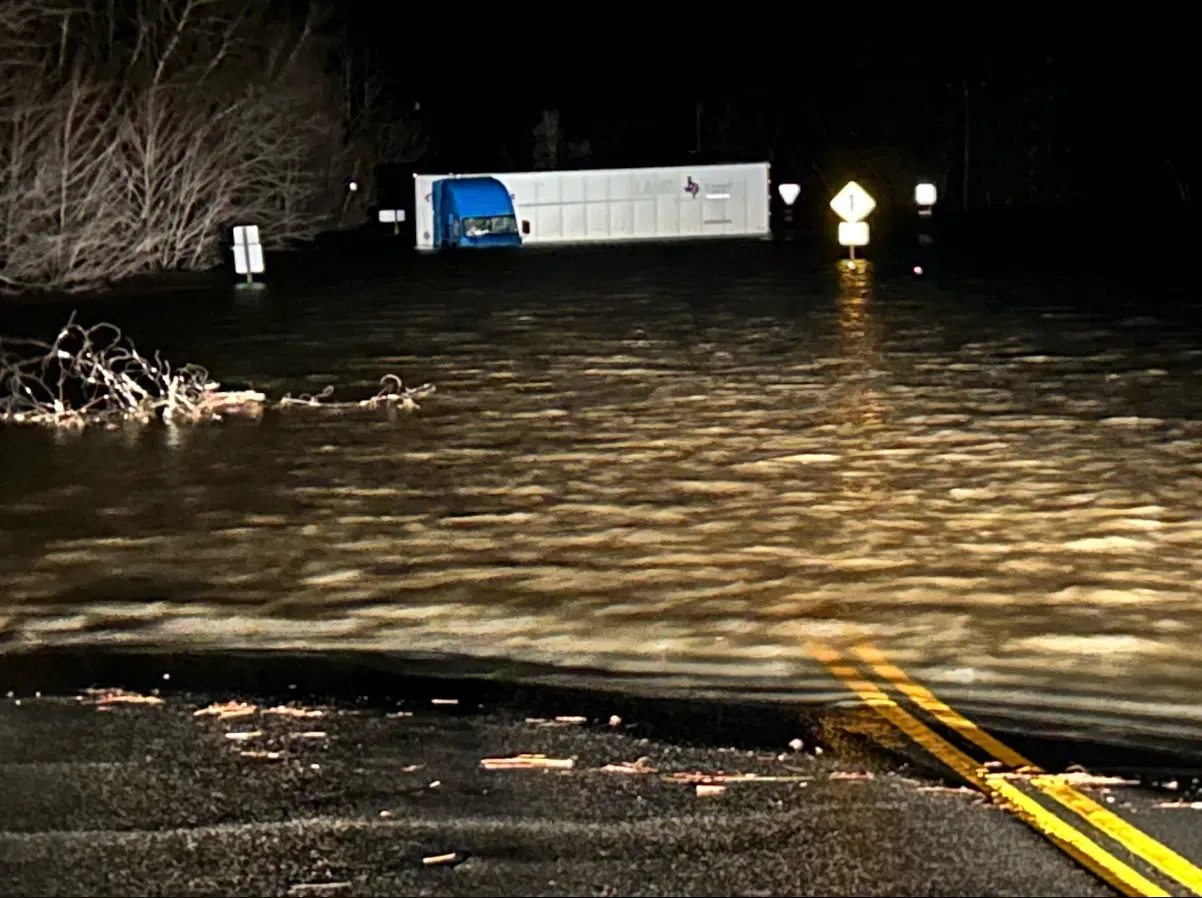


Photos: Flooding and damage in Maine (Central Maine Power); Water rescue in Rhode Island (NECN); Flooding in Maine (Billian Moments Photography); Road damage in Maine (Angie Cuff); Flooded out road (WGME); Wind damage in Augusta (Maine Capitol Police); Flooding in Jackson, New Hampshire (AccuWeather); Coastal flooding in Rhode Island
New England Storm Center's coverage of this event when it happened:
2. Rhode Island's EF-2 tornado (August 18)
Tornadoes in New England are not quite as rare as some may think. Every summer, a handful of tornadoes touch down across the region. What is rather rare is for one of these tornadoes to become strong. New England Storm Center has been keeping a log of tornadoes in New England since 2008. Of the nearly 150 tornadoes in this log, Rhode Island's August 18th tornado became only the fourth to reach EF-2+ status.

This tornado was the strongest in New England since 2014 and the strongest in Rhode Island in nearly four decades. The tornado touched down in Scituate, Rhode Island, moved through Johnston and dissipated in North Providence. The tornado tracked just over 9 miles and reached a peak wind speed of 115mph, causing significant tree damage as well as some structural damage. Along its path, the tornado crossed Interstate-295, where a car was lifted off the ground, injuring the driver.
August 18th would see a total of five tornadoes touched down across New England. This day would become only the fifth day in New England since 2009 to produce at least five tornadoes in the region.

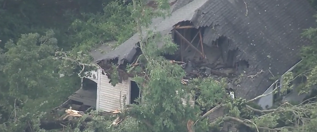


Photos: Structural damage in Rhode Island (WCVB); Tree damage in Scituate, RI (Joanna Bouras); Damage in Brockton, MA (Chris Grazioso); Roof damage in Rhode Island (WHDH); Car that was lifted by tornado (NBC10 Boston); Tree damage in Scituate, RI (NBC10 Boston)
New England Storm Center's coverage of this event when it happened:
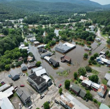
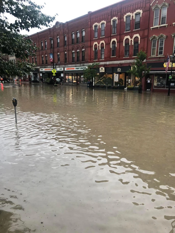
1. The great flood of 2023 (July 9-11)
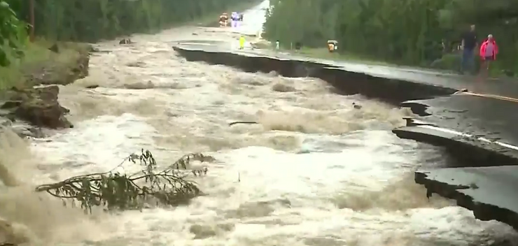
Vermont has experienced a few extreme flooding events in the state's history. 1927, 1973 and 2011 all saw massive, devastating flood events in Vermont. 2023 can now be added to that list. A storm system arrived in New England late on July 9th and continued to pound western New England with rain for over the course of the next two days. Rainfall totals of 4-8 inches were widespread across the Green Mountains with a high of 9.2 inches in Calais.

What was especially interesting about this storm is that it was not one powerful low pressure system (like a nor'easter), nor was it a tropical cyclone (like Irene). This storm was created by a few pieces of energy, none of which stand out on their own, that happened to align just right in a primed environment to create a flood disaster.
With this event occurring just 12 years after Irene, it's only natural to compare the two for reference. When asked about this storm compared to Irene, Ludlow, Vermont's town manager stated "the same, if not worse." Ludlow was one of the towns hit especially hard by the flooding. The Winooski River rose two feet above Irene's flooding in 2011. The Lamoille river rose four feet above Irene's levels. Montpelier saw its wettest single day since records began in 1948 with 5.28" falling on July 11. This beat the previous record set by Irene by 0.1". Montpelier was hit very hard by both flash flooding and river flooding at the same time. In our initial article for this event, we wrote:
"The Wrightsville dam is approaching capacity and may need to be released to avoid a failure. This would cause even worse flooding in Montpelier. The city is just about cutoff, so evacuation options are very limited for anyone still in the city. Officials told anyone in the city that their best bet at this point would be to head to the highest level of your home or building."
The Wrightsville dam stabilized without breaching the spillway.
Well over 100 water rescues, about 70 separate evacuations from homes and buildings and over 100 major route closures occurred during the storm. A spokesperson for Vermont Agency of Agriculture, Food, and Markets stated over 7,000 acres of farmland were lost.A month after the flooding, 1,100 sites of damage on state-maintained roads and bridges and 826 damaged culverts were identified. Over 4,000 tons of debris have been moved out of damaged areas. Just 12 years after Tropical Storm Irene set the benchmark for modern flooding in Vermont, the 2023 floods have challenged this benchmark.


Photos: Mudslide in Barre (WCVB); Flooding in Johnson (VTCNG); Road damage in New Hampshire (WMUR); Flooding in Ludlow (Henry's Weather Channel); Flooding in Montepelier (Bill Fraser); Resue in Montpelier (Neal P Goswami); Flooding and damage in Ludlow (Pat Moore); Weather Prediction Center's risk for flash flooding on July 10 (Weather Prediction Center)
New England Storm Center's coverage of this event when it happened:
Комментарии