Faster-Moving System on Tap for New England Wednesday Night
- Tim Dennis
- Apr 1
- 3 min read
High pressure will build over New England today into Wednesday. This will bring about a cold start to Wednesday. Much of the day will be dry, calm and cooler under a ridge of high pressure and dry air. The day will see increasing clouds from west to east as the next system approaches for Wednesday evening through Thursday. A frontal system will slide across the Great Lakes on Wednesday and travel north of New England Wednesday evening through Thursday.

Initially, the air mass appears cold enough to support mostly snow across much of interior northern New England Wednesday evening and going into the first part of the night. As the warm front lifts northward, it will introduce a warm nose of air aloft, allowing for snow to switch over to a wintry mix from south to north. The change from snow to rain will likely follow a rather linear transition with snow to sleet to freezing to plain rain as the warmer layer of air gradually deepens.
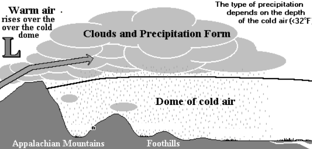
There remains a strong signal for cold air damming (when a layer of cold air is trapped at the surface below a dome of warmer air) across northern New England. Guidance often struggles with cold air damming situations in the springtime. This is because the ever-strengthening spring sun angle makes it easier for the surface to warm above freezing then otherwise would be the case in the winter.
Below: Diagram of cold air damming:

With that said, the bulk of the system will likely move through New England overnight Wednesday into Thursday morning, when temperatures are at their coldest and the sun is not a factor. A more prolonged period of sleet and freezing rain will be possible across the northern tier of New England.
A switch to plain rain will occur from southwest to northeast through the event as the surface warm front lifts northward. The progression of the warm front has trended slower and farther south over the last 24 hours, but a transition across all of New England remains likely as daytime heating comes into play Thursday.

The amount of wintry precipitation at the onset will come down to how quickly (or slowly) the cold air at the surface can scour out. With the system arriving in the overnight hours when temperatures are coldest, it will support at least some wintry accumulation across portions of the north.
At this point, accumulations of both ice and snow look to be more minimal. It looks like 1-3 inches of snow across northern New Hampshire and much of interior Maine, with amounts gradually increasing moving northward (and higher in elevation, of course). Vermont will likely see lesser amounts as the warmer air from the southwest arrives earlier.
Below: Probability of at least 1 inch of snow Wednesday into Thursday morning:

As for potential icing, the warm nose aloft will again be more pronounced while cold air damming holds the low-level cold air in place, allowing for a more prolonged period of freezing rain and sleet in most areas. With that said, this storm will be much more progressive than the one that was with us last weekend that brought a half inch to nearly a full inch of ice in some communities. Current trends currently point toward 0.1-0.25 inches of ice (freezing rain accretion and potential sleet accumulations combined).
Below: Probability of at least a glaze of ice Wednesday to Thursday morning:

There will be copious amounts of moisture for the system to work with across northern New England, with QPF decreasing moving southward in the region. This moisture will be advected northward on a strengthening low-level southerly jet from the Mississippi Valley. This will also help transport the warmer air into New England. This could also result in a period of gusty winds.
With less moisture and more warmth across southern New England, this period will be milder with all rain showers. The system will likely be more showery in nature rather than a widespread shield of steady rain. The warm front will rise into southern New England Thursday afternoon, putting the area in the warm sector. Even with extensive cloud cover, the incoming air mass will likely support highs in the mid 50s to mid 60s.
Below: RGEM showing potential temperatures Thursday afternoon:

Spring is the time of the slow-moving weather system, and it looks like another slower mover will be arriving this weekend. Several waves of energy look to traverse the northeast from later Saturday through Sunday night, though precipitation onset time remains uncertain. This will once again be rain showers for southern and central New England with the potential for mixing across the northern tier.
Below: Current weather map for Sunday morning (April 6):


Comments