Colder Air Arrives This Weekend and Remains in Place for New England
- Tim Dennis
- Jan 3
- 4 min read
It was a windy and (in some select areas) snowy day across New England yesterday. Both the wind and the mountain snow showers will gradually slow down through the weekend. The snow will largely shut off through today, but the winds will remain elevated through the weekend. This is coming thanks to a storm that is nearly stalled over the Canadian Maritimes. Broad cyclonic flow will continue around the system, leading to gusty winds and falling temperatures amid the strong northwest flow.

The winds will not be as strong as they were on Thursday, when widespread gusts of 50-60mph were observed across much of the region. Widespread gusts of 30-40mph will occur Friday across the region. Saturday and Sunday will see winds slacken a bit (albeit still noticeable) across northern New England while southern New England remains around the 30-40mph range.
This wind will continue to usher in a much colder air mass than the region has been under over the last week or so. This push of colder air into the region will suppress a snowstorm to the south of New England early next week. This storm is poised to bring a swath of 4-8+" of snow (along with ice) across the Ohio Valley and into the Mid-Atlantic. This storm will get shoved south of New England as cold, dry air continues to push into the region. The northernmost snow showers may still be able to get into southern New England, but accumulations should remain light.

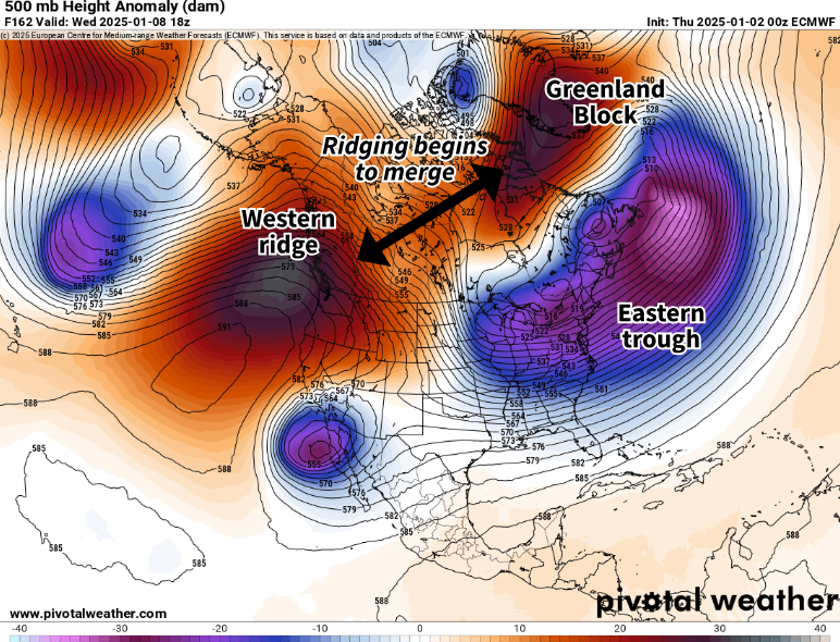
The cold air setting up this weekend will have serious staying power for a while. A rather strong Greenland Block will set up, leading to persistent troughing over the northeast. In addition, ridging over the western United States and Canada will also be in place. These two features are expected to begin to gradually merge heading into next week.
This will set up a Rex Block-type situation (where a ridge sits directly north of a trough). This supports cold air getting locked across the eastern half of the United States amid the troughing. This pattern will hold strong through next week and possibly all the way through mid-January. This will keep persistently wintery temperatures around for much of the month, something that hasn't been the case in recent winters.
Below: 500mb height anomaly showing troughs and ridging around mid-week next week:

The core of the coldest air relative to average is expected to move to New England's west and south through mid-week. This will bring about persistently sub-freezing temperatures to New England, but not truly bitter or Arctic compared to what could have come. In fact, eastern and northern Maine may stand to rise a bit above average next week being closest to the ridge (as well as seeing some warm air advection from the movement of the stalled low).
Below: Temperature departure from average average next Wednesday (January 8), showing cold temperatures over New England, but not to the extent of areas farther west or south:

This will be a pattern of persistence, with this cold snap likely being defined by its duration. Most of New England will remain sub-freezing from Saturday through all of next week and possibly into the week after as the pattern slowly evolves. The block over Greenland is expected to very gradually weaken as we move toward the middle of the month.
The southward center of this cold air can be seen on the Climate Prediction Center's 6-10 day outlook. Much of southern New England has up to an 80% chance of below average temperatures while chances drop heading north and east in New England. Temperatures may drop a notch colder late next week for New England compared to this weekend and the start of next week.

The cold temperatures moving into the United States are supported by a weakening Arctic Oscillation (AO). The AO Index will reach strongly negative territory next week. The index is expected to drop to around -4. For reference, the lowest this index has been observed is -4.27, which occurred in February of 2010. Add in a negative North Atlantic Oscillation and a positive Pacific-North American Oscillation, and the recipe is there for a cold January.
While there are many factors that go into what temperatures will be, a negative NAO can support colder weather over the east while a positive phase is the opposite. A negative NAO doesn't automatically mean cooler weather is coming (if it did, long range forecasting would be much easier), but in this case, the other factors will be lining up.
Below: AO Index values for the last four months. The solid black line represents observations dating back to mid-September while the dotted line represents the upcoming forecast through mid-January:

The coldest air masses tend to be the driest ones, and the air mass that will be persistently cold is poised to keep precipitation at bay for the most part. Greenland Blocks tend to support nor'easter development for New England, the issue is that the jet stream may get pushed so far south, it keeps developing storms well away. For a snowstorm during this time, New England will need the right balance of a cold air intrusion and jet stream position.
Snow showers, mainly in the mountains, will remain possible through early next week. That storm early next week may be able to squeeze out some flakes for southernmost New England as well. Other than that, this is a cold and dry air mass over the region.
Below: Current 7-day precipitation forecast:

Comments