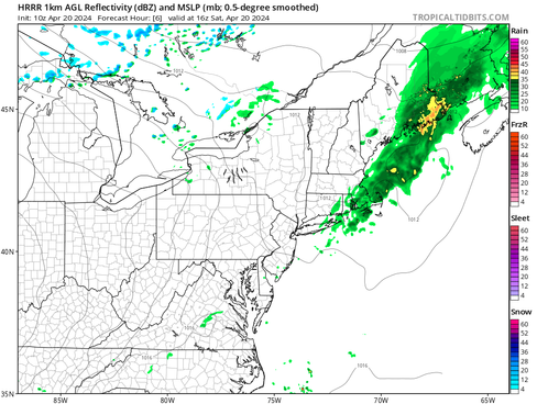
Rain from a passing cold front will come to an end this morning for most across New England. Downeast Maine will remain in the steadier rain through mid-afternoon. The cold front likely won't clear New England completely until Sunday morning. Broad cyclonic flow will continue for the region Saturday afternoon, which will likely result in some scattered showers popping up in the afternoon. The air will be drier after the front crosses, so any showers that do pop up in the afternoon would be brief and light.
Expected weather around midday Saturday (1st image) and Saturday mid-afternoon (2nd image):


After this, New England should get a break in widespread precipitation through the middle of next week. A weak ridge of high pressure sets up for Sunday and Monday. It will be breezy both days, with gusts of 20-30+mph. A rather strong cold front will drop into New England Sunday night through Monday. While this frontal passage will be mainly dry, scattered rain/snow showers will be possible across the northern tier of New England Sunday afternoon and evening.
Weather map for Monday morning:

This front will provide a strong shot of colder air into the northern tier of New England for Monday, particularly northern Maine, where it will be downright cold. Wind chills will drop into the teens and 20s to the north Monday morning with 30s to low 40s in southern New England. Afternoon highs will recover only to the mid 30s to mid 40s across the northern tier while central and southern New England get back closer to seasonable levels, mainly the 50s.

Temperatures will generally be up and down next week, but may end up hanging around seasonable levels, with no major spring-time warm ups (or cool downs after the brief one for some on Monday) in the picture. A southerly flow ahead of an approaching system for the middle of next week will likely boost temperatures on Tuesday. Temperatures will likely drop again after a frontal system moves through on Wednesday and Thursday.

That frontal system for the middle of the week will likely see an area of low pressure form and intensify along it as it passes through the region. As of right now, the dynamics of the storm don't look overly impressive with PWAT values (amount of moisture in the air that could become precipitation) remaining below an inch. This wouldn't support a soaking rain. A low-level jet is currently forecast at 35-45mph, another less than impressive dynamic.
With that said, there remains a spread in just how strong a surface low will get over New England. With that in mind, there is still room for the system to trend stronger or (weaker still). Either way, there will likely be widespread precipitation heading into the middle of next week. The system will become cooler on the back end, which could support a switch to snow in the mountains and northern Maine Wednesday night. The timing and position of the low pressure system will determine the extent of any frozen precipitation.
Weather map for Wednesday morning:
