At the very beginning of October, we titled a "New England Weather This Week" article as Summer's Last Gasp. We led off that article with "This week will, in all likelihood, be summer's last gasp before fall takes over for the season." Despite the likelihood of that being summer's last gasp, here we are, on Halloween weekend, talking about record highs, 80s and even some humidity.
Of course, upper 70s to low 80s is more September-like than the true middle of summer. In early October, the region was pushing 90°, so maybe the early October heat should remain titled "Summer's Last Gasp."
Anyway, this very late season warm spell is on the verge of coming to an abrupt end. A cold front will be dropping through New England throughout the day today. This front will usher in a much cooler air mass. The front will not cause a sharp drop in temperature. Instead, the air will gradually cool after the passage of the front. The front will be a mostly dry passage as well, with some scattered, light showers possible in northern New England.
Weather map showing the cold front location by early afternoon Saturday:

With the front already pushing through the northern third of New England, the temperature will not be warming up, but instead falling throughout the day. Burlington, Vermont has hit its high for the day and will now be dropping (as of 9:30am). Southern and central New England will be warming to near record highs before the front makes passes, with highs in the mid 70s to low 80s likely.

The temperature will really begin to cool once the sun sets and the front has completely cleared the region. This front's true impact will be felt on Sunday, as high temperatures will not rise too much from overnight lows, likely rising no more than 5°. This will lead to a very chilly day. Along with the new chill, there will be a thick cloud cover developing from west to east along with showers from an incoming storm system.
Expected weather Sunday afternoon showing showers moving generally west to east:

This rain will continue to become more widespread through Sunday evening through the overnight hours to Monday morning. There will be periods of on and off rain throughout the day Monday across all of New England with continued chilly temperatures. The showers will begin to wind down from west to east Monday afternoon.
Expected weather Monday around midday:

Highs Monday will likely be in the 40s and 50s across New England with some higher elevations of northern New England, along with northern Maine failing to get out of the 30s. This will support snow across northern Maine and northern New Hampshire Monday morning. The first snowfall of the season for New England outside of the mountain tops is looking likely. It will be difficult for snow to accumulate given the warm ground after the past few days, but a couple of inches is looking increasingly likely for northern Maine.

As far as rain goes for the rest of New England, a widespread half an inch to an inch is likely through Monday evening. Halloween itself is looking to be a dry and bright day for the region, albeit remaining chilly, with highs in the 40s for most.
Another system, likely a coastal storm, will make a pass at New England around mid-week. Yesterday, we mentioned this storm and noted that models varied widely on the outcome. Today...not much has changed. Some models are showing the system passing well offshore of New England, keeping any precipitation spotty and mostly across southeast Massachusetts while others show a closer pass that would allow for mixed precipitation or snowfall across southern New Hampshire, Maine and the higher elevations of southern New England.
Euro Model vs GFS for Wednesday morning, continuing to show two very different outcomes. Either way, this doesn't look to be an overly significant storm:

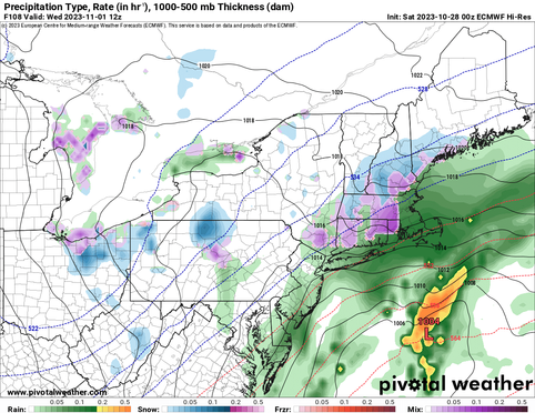


No matter what the mid-week storm does, the temperatures will remain chilly, with highs remaining below average for most of the week. Highs will hang around the 40s to low 50s through at least Thursday. There are signals of a warm-up back to at least average by late next week.
Comments