This Saturday will be yet another soaker for most of New England. This will come as a strong cold front pushes through New England from the west. As this happens, the remnants of Tropical Storm Philippe (the storm will become post-tropical in the Gulf of Maine) will likely pass into eastern Maine. Philippe will infuse the frontal system with tropical moisture, allowing heavy downpours to occur Saturday and Saturday night. These downpours will be focused on two areas across New England.

While the approaching front will create a lot of clouds, and some showers in western areas on Friday and Friday night, the main event will arrive on Saturday. Steadier rain and more widespread showers from the cold front will likely enter into western New England by Saturday morning and gradually push eastward during the day. Heavy rain from Philippe will enter into Maine by Saturday afternoon.
Right now, it appears that the heaviest of the rain will fall across New England Saturday evening through Sunday morning. Despite this, there will be a constant chance for showers beginning Friday evening. Saturday afternoon and night is likely when downpours will be most numerous. These downpours will be most common across western New England (Vermont, Connecticut and the Berkshires) as well as Maine. These two areas will have the best chance at seeing multiple inches of rain.
Euro Model showing expected weather Saturday afternoon. You can see two distinct areas with the heaviest rain, western New England (from the frontal system) and Maine (from Philippe):

Downpours are looking to be less common across southern New Hampshire, central and eastern Massachusetts and Rhode Island. While the downpours are looking to be less common, it won't be dry in these areas, there will just be less overall rain.
The big question right now is where exactly Philippe tracks. Models seem to be homing in on the storm impacting eastern Maine, however, the track of Philippe has changed significantly over the past 36 hours. If the track jogs westward (closer to the Mass coastline), heavier rain would be pushed further into eastern Massachusetts and Rhode Island. Right now, it does appear that the heavy rain from Philippe will be contained to Maine and Cape Cod, but Philippe's track will be something to watch.
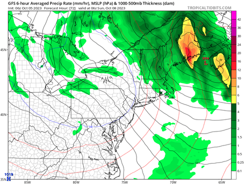
Philippe's heaviest rain will likely impact Maine overnight Saturday night into Sunday morning. Drenching rains will be possible across most of Maine. It looks like the further east you go in Maine, the higher the chance for heavy rain, but this will be dependent on Philippe's final track.
GFS and Euro Model showing expected weather overnight Saturday to Sunday. Euro has the heavier rain from Philippe pushed a bit further west. You can also continued rain over the rest of northern New England as Philippe and the frontal system merge:


By Sunday morning, the frontal system and Philippe will have merged together and will be moving north of New England. Sunday will see conditions dry out for most of New England. Lighter showers will likely continue for the White and Green Mountains. By Sunday afternoon, a vast majority of New England will likely have seen at least a half an inch of rain with 1-3 inches across the Green Mountains, White Mountains and much of Maine.

At this time, widespread, significant flooding is not expected. Some rivers have the possibility to reach minor flood stage in Vermont and Maine, but a vast majority are not forecast to reach flood stage. Vermont is being aided by the fact that it has now been several weeks since the last appreciable rainfall for most of the state, so soils have dried out and rivers are running lower.
Flash floods are a possibility, but not expected to be widespread at this time. Overall, flooding issues are looking to be minor/nuisance rather than bigger issues. This will be dependent on trends, so this threat could increase or decrease by Saturday, stay tuned for updates.

Winds will also be gusty with Philippe in Maine. Winds will be concentrated more on the east side of the system, so Downeast Maine would likely see the highest wind gusts. Maximum gusts of 40-50mph will be possible. Gusts of this strength are generally below the threshold for tree damage, but wind advisories may be posted for the storm as heavy rain will saturate soils, making trees easier to uproot. Overall, impacts from Philippe in Maine will be less than that of Lee.
Comments