A robust Alberta Clipper system will pass to the north of New England on Wednesday. This system will likely form a secondary low along its triple point (where the warm front, cold front and occluded front meet). This will allow snowfall rates to become enhanced, especially for the White Mountains and eastern Maine.

TIMING
Scattered snow and rain showers will develop across much of New England throughout the day today, mainly in northern New England, as the warm front lifts into the region. Some snow squalls will be possible across the higher terrain, leading to a quick inch or two of snow.
Expected weather around midday today:

As the cold front swings into New England this afternoon and evening, it will reignite another round of snow showers to the north and rain showers to the south. At this time, a secondary low will begin to form. This will allow steadier snow to begin to fill in across portions of northern New England, mainly the White Mountains and western Maine.
Expected weather late-afternoon:

As the secondary low intensifies rapidly over Maine, it will lead to ever-increasing snowfall rates as the system moves into eastern Maine. Exactly where this secondary low sets up, along with how fast it is able to intensify, will determine where the heaviest snow sets up. That is a tricky call. It's safe to say that eastern Maine, away from the coast, will see the most snow.
Expected weather overnight tonight into tomorrow morning:

SNOWFALL
The initial snow showers during the daylight hours on Wednesday won't amount to all that much. As the system intensifies, it will create heavier snowfall rates. This will likely start across New Hampshire, but the system will likely be moving into Maine at this time. Vermont will see the least snow as the system will be past by the time it gets organized. Some of Vermont may be able to pick up a quick couple inches from potential snow squalls.
Eastern Maine will see the most snow out of this system. Here, over a half a foot is looking increasingly likely. Intense snow banding will likely occur as the system intensifies. Exactly where these bands set up is where the tricky part of the forecast comes into play. The biggest uncertainty in snowfall lies along Downeast Maine. This comes as it's hard to say just how close to the coast the heavier snow will get. Coastal areas will see less snow than interior areas.

As stated above, a narrow band of intense banding is possible in eastern Maine. This banding will set up just northwest of where the secondary low tracks. Snowfall rates in this banding could become 1-2 inches an hour for a time. Should this materialize, there could be a narrow window of 8+ inches in eastern Maine.
There is a good amount of bust potential with this system. Warm conditions preceding the storm will make it difficult for snow to stick initially. With marginal temperatures in areas, just a degree or two difference could mean rain or a mix rather than snow. There is a higher amount of uncertainty at this close range than usual. This can be seen in winter Storm watches for eastern Maine. The fact these are not warnings or advisories as of Wednesday morning speaks to the uncertainty.
Southern New England will see minimal snowfall in the Berkshires and Worcester Hills. Some flakes may mix in elsewhere, but this will be a rainy event for Lake Winnipesaukee points south with a bit of snow on the backside, amounting to very little or nothing.
RAINFALL
Rain showers across southern and central New England will be non-impactful with less than a quarter inch expected. It is possible for some areas to briefly see a heavier shower and even hear a rumble of thunder, but there are no flash flooding concerns.
WIND
Winds will become strong after the frontal passage. Winds will begin to crank in the early morning hours Thursday across western New England and will encompass all of New England by midday Thursday. Gusts are not expected to reach widespread impactful levels. Gusts of 30-50mph will be common throughout Thursday across most of New England. This could result in some isolated power issues, but outage numbers should remain low.

The biggest impact from the winds will be across areas that see several inches of snow overnight. This wind will likely create blowing and drifting snow, leading to continued reduced visibilities.
This wind will usher in a much colder air mass than what we've been in. While it won't be truly arctic, it will feel very cold after such a mild past month or so. In the end, highs will likely top out just below average for New England, but the wind chill have an extra bite.
THE WEEKEND STORM
The overall thinking on this weekend's storm hasn't changed too much. That is to say a mainly rain event is likely in southern New England with accumulating snow in interior northern New England. There remains a spread in potential tracks up the coast, which makes it difficult to try to go into too much detail.
As of now, most signs point toward a rain/snow line working from south to north through the day on Saturday. Naturally, the farther south you are, the quicker the snow will change to rain meaning the less snow you'll see. This storm will likely remain mostly snow in the higher elevations of northern New England and the valleys north of Lake Winnipesaukee. This is the current trend and subject to change until the track gets sorted out.

A decent slug of snow is possible across ski country with the potential for 6+ inches across the Green, White and Maine mountains. As usual with spring snowstorms, elevation will likely play a large role in snow totals. A decent slug of rain will be possible across southern New England, where areas could see up to over an inch.
The amount of precipitation that falls will be heavily dependent on the level of phasing between the northern and southern stream energy pieces. The main southern stream energy is looking like it will get cut off in the southeast US, however, a piece of that storm will likely shear off and head for New England.
This is what will be phasing with the northern stream. The amount of energy that heads to New England from the southern stream and the level of phasing between that and the northern stream will determine how heavy the snowfall and rainfall rates get.
A NOTE ON A.I. WEATHER MODELS
There's been some talk over the past several months about the new A.I. driven weather models, and whether they represent the next major advancement in weather forecasting. Earlier this year, ECMWF (owners of the beloved Euro model) launched an A.I. version of the Euro model. This model is known as AIFS (Artificial Intelligence/Integrated Forecasting System).
New England Storm Center used AIFS for the first time earlier this week when looking at model runs for this weekend's upcoming storm. At this time AIFS and the traditional Euro model were showing two very different outcomes. At this point, it does appear that the traditional Euro model has moved toward what AIFS was showing earlier in the forecast period.
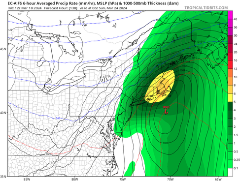
Traditional Euro model (1st image) and AIFS (2nd image) model runs on Monday morning (March 18) showing precipitation for Saturday night. You can see quite a range between the two. NOTE: This only shows precipitation, not precipitation type:


This comes as AI weather models have claimed to be more accurate than physics-based models. This is just an observation we've made and are not trying to make any claims of our own at this point. AI forecasting is still very new. New England Storm Center has sporadically shown GraphCast (another AI weather model) in some forecast posts. For the record, New England Storm Center does NOT use AI to write forecast posts. All articles are human-written.
Traditional Euro model (1st image) and AIFS (2nd image) model runs this morning (March 20) showing precipitation for the same time frame as the runs above. You can see the traditional Euro has aligned more closely with AIFS:


Comments