Bout of Rain, Gusty Winds Incoming to New England
- Tim Dennis
- Mar 5
- 5 min read
A mature frontal system over the Great Lakes will push north and west of New England Wednesday into Thursday. A deep southerly flow will develop ahead of this system on Wednesday, allowing temperatures to continue to climb. This will inject plenty of moisture into the storm, allowing for a soaking rain event region-wide. While the overall effects from the storm (rain/flooding, wind, coastal flooding) won't be overly impactful, some rivers will need to be monitored.

As warmer air continues to advect into New England, it will allow for showers well ahead of the main storm's arrival later tonight. These early showers will primarily be focused across northern New England through this afternoon, though spotty showers could pop up anywhere. Showers will continue to fill in across the entire region from southwest to northeast through the evening and into the overnight hours. The bulk of the storm will push through during the overnight hours for a majority of New England.
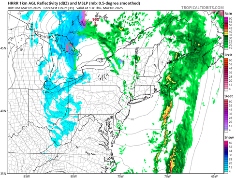
Below: HRRR showing potential weather early this afternoon (1st image) and around midnight tonight (2nd image):


The main line of steady rainfall with embedded heavy downpours will be rather progressive, pushing into eastern Maine by Thursday morning. The main bout of rain will likely push out of New England completely by midday Thursday, leaving New England in the warm sector of the system. Some pop-up showers will likely be around through the afternoon. These showers could pop up anywhere in the region.
Below: HRRR showing potential weather Thursday morning (1st image) and around mid-afternoon Thursday (2nd image):


There hasn't been much change in thought over the past 48 hours regarding total rainfall amounts. A widespread half inch to inch of rain remains likely. Over an inch of rain will be most likely across southernmost New England, the White Mountains and Downeast Maine. The Champlain Valley stands to pick up the least rain. Overall, rainfall totals may be varied across all of New England due to the scattered nature of potential downpours.

The storm will have a clear connection to high Gulf moisture. The line of storms extends all the way to Florida this morning. With a strong southerly flow and warm advection, this plume of moisture will have little trouble making it to New England. This will allow for widespread moderate rain with the potential for briefly heavy downpours to develop as forcing ahead the storm's cold front increases Wednesday night.
Below: Precipitable water values Wednesday evening, showing a conveyor belt of moisture moving into the northeast:

The snowpack across the mountains and far northern areas remain very cold. This means it will take time for the snow to "ripen" to the point of rapid melting. This may help limit the overall snowmelt and runoff coming off the mountains and north country. The snowpack will eventually ripen in these areas and be ready for faster melting by Thursday morning, but cooler temperatures won’t be too far behind by this point.
Overall, 1-2 inches of snowmelt is expected to be added to the rainfall across many areas of northern New England. Northern Maine (including the higher elevations) is expected to see little snowmelt and runoff due to the cold nature of the snow. This will allow the snow to absorb the rain. Areas that have the best chance to see closer to (or over) 2 inches of snowmelt are generally better equipped to handle it, especially without significant runoff from the mountains.

The overall risk of widespread flooding issues remains on the lower end region-wide (hence the lack of flood watches). Rivers are forecast to rise as the ground is frozen, so all of this water will run off. At this point, the rises are not forecast to reach flood stage. Several rivers are forecast to hit action stage (Mad River, VT; Otter Creek, VT; Winooski River, VT; Hoosic River, MA; North Nashua River, MA; Warner River, NH), so rivers will need to be monitored heading into Thursday. Issues are expected to be more isolated in nature.
The greatest flood threat will likely come from potential river ice breakup and ice jams. As of now, river ice across the north ranges from 6-12+ inches. Areas that have a thicker ice cover (over 12 inches) will have a lower chance of ice movement and potential ice jam issues. Areas that have around a foot of ice thickness would need river rises of 2-3 feet to move the ice, which could occur as rivers are expected to rise rather sharply.

A robust low-level jet of 70-80mph will also cross the region Wednesday into Wednesday night, resulting in a period of gusty winds. The level of winds has been the most difficult part of this storm to figure out as there are factors working for and against stronger gusts making it to the surface. On one hand, a strong inversion will likely play a major role in limiting gusts. On the other hand, modest pressure falls and the potential for heavier precipitation rates may assist in some stronger gusts breaking through this inversion.
Below: Low-level winds overnight Wednesday (1st image) and Thursday morning (2nd image):


Overall, widespread gusts of 40-45mph will be possible across much of the region. Southeast Massachusetts and Maine's coastline will have the best chance to see some gusts of 50-55mph. Farther inland, a cold snowpack and a more stable environment will make stronger wind gusts difficult to achieve. Wind advisories have been posted for much of Maine's coast. Southeast Massachusetts/Rhode Island is very close to the advisory threshold and it wouldn't be surprising to see a wind advisory posted there later today.
One last quick note about this storm is the potential for some minor coastal flooding. A persistent southerly wind could lead to splashover or minor coastal flooding across the south coast of New England. This threat is low overall, and minor coastal flooding appears to be a worst-case scenario. Coastal flood advisories and statements have been issued. Astronomical high tides are now on the decrease, which will help this situation.
The storm's cold front will cross later Thursday, bringing colder temperatures back to New England, though certainly not arctic. New England is more likely to drop back to near seasonal averages. As per usual with the day after storms, it will be gusty on Friday. Winds will likely be stronger on Friday than they will be Wednesday night.
Below: Euro showing potential wind gusts Friday afternoon:

The storm will likely continue to strengthen as it moves away, and could swing some snow showers into eastern Maine during the day. Typical upslope snow will also be possible in the mountains. Other than that, it will be dry. Heading into the weekend, a few weak, northern-stream disturbances look to cross New England, bringing periods of light and scattered snow/rain showers, but nothing noteworthy.
A southern stream system looks to stay well south of New England during this time. There was a very brief period of excitement (if you want to call it that) earlier this week about potential phasing between this and one of the northern streamers this weekend. That has since faded as quickly as it appeared and the storm will very likely stay well south of the region. We didn't bother bringing it up earlier this week as it was never favored outside of one rogue model (run) and a few ensemble members.
Comments