Another Winter Rain System Incoming to New England; Unsettled Afterward
- Tim Dennis
- Dec 26, 2023
- 3 min read
There are some unsettled times ahead for New England's weather. This bout of wetter weather will begin with a system passing New England Wednesday afternoon through Thursday. Unlike our previous couple storms, this one will not be a multi-hazard storm. It will bring parts of the region another round of steady rain.
This system will follow the same general pattern as our last two storms, only this storm is much weaker with far less impressive dynamics. A coastal low pressure will develop off the Mid-Atlantic coast and work northeast through New England. Trends over the past 48 hours have moved the storm generally further south. This, in turn, limits the steadier rain to southern and central New England.
With no cold air in sight, this will be another rain storm for most of New England. There will be a stationary front stalled across northern New England during this time. This will help keep the storm all rain south of it while allowing some snow/mixing to occur to the north of it.

Showers will likely begin across western New England Wednesday afternoon and evening with the stationary front providing some light mixing/snow showers across northern Maine. The showers will spread east through the night Wednesday into Thursday morning. The steadiest of the rain will likely be early Thursday morning in southern New England. Northern New England will likely see continued lighter showers.
Expected weather Wednesday evening (1st image) and Thursday morning (2nd image):

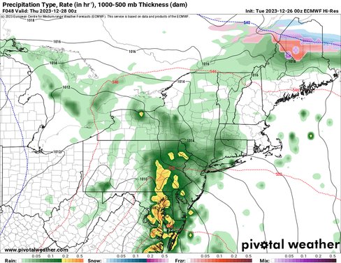


Despite a southerly flow once again boosting moisture in the atmosphere, rainfall amounts are generally looking to remain below impactful levels. The further south in New England you go, the more rain is likely to fall. Rain will likely stay below an inch for most areas, though western Connecticut and the south coast could see up to an inch.

As for snow in northern Maine, precipitation will generally be pretty light as the storm passes well to the south of the area. An area of high pressure to New England's north will help provide the colder air in northern Maine, but also eat away at some of the precipitation. Amounts will likely range from a dusting to two inches through Friday morning.
After the bulk of the storm, it will slowly exit Thursday afternoon. New England will remain in a trough and under cyclonic flow, which will lead to continued clouds and scattered showers Thursday afternoon right through Saturday morning.
As of now, these showers (rain and snow) are looking to be rather light and scattered in nature, however, if a more organized low is able to develop, there could be more widespread precipitation Friday afternoon into Saturday morning with a chance for some light snow accumulations across the interior. This will be something to watch over the next 24 hours or so.
CMC showing potential weather Friday evening (1st image) and Saturday morning (2nd image). You can see the low develop, bringing the chance for more widespread precipitation:


The stalled frontal boundary to New England's north will drop through New England by Friday, leading to a cool down across New England. The week will start off mild and continue that way through Thursday. After the front drops through New England, it will lead to more average temperatures Friday and into the weekend.

This unsettled weather pattern does look to break by Sunday, just in time for the New Year's holiday as the trough looks to move offshore and brief ridging builds into New England. A trough is looking to dig into the Great Lakes this weekend, so this will need to be watched heading into next week.
Comments