The weak cold front that moved into New England on Independence day will remain draped over New England, allowing for continued periodic showers and storm chances through Saturday night. For Friday, a morning wave of scattered showers across New England will be followed by some redevelopment of showers in the afternoon and evening.

Heading into this afternoon, the thick cloud cover should begin to get scoured out somewhat, though there will still be plenty of clouds around, similar to yesterday. The best chance for an afternoon storm will be across western and northern New England, where there will likely be a quicker breakup to the clouds, allowing for better daytime heating and instability to build. Chances for a storm drop as you get closer to the coast.
These storms will likely begin to fire up in the early afternoon across southwest New England before filling in somewhat as the afternoon progresses. Storms may never truly become widespread across New England as forcing is weak. With that said, this air mass is very humid, and with CAPE values likely building over 1,000, it won't take much to get a storm going.
HRRR showing potential weather late this afternoon:

This setup is not indicative of severe weather for New England. The stronger storms are generally expected to remain to New England's west, closer to the system's cold front. The biggest threat from any developing storm will be the chance for torrential downpours as the atmosphere is moisture-rich. Precipitable Water (PWAT) values will likely build to 1.75 to 2.15 inches. Values getting near 2 inches indicates a highly moisture-rich environment where heavy rainfall rates are possible assuming storms can develop.
PWAT is defined as the amount of water vapor contained in a column of air if it were to be condensed and collected. Basically, the higher the PWAT value, the heavier the rainfall rates can get. The PWAT value does NOT correspond to how much rain is expected to fall, meaning that a PWAT of 1.75 to 2.15 inches does not immediately mean 1.75 to 2.15 inches of rain is expected.
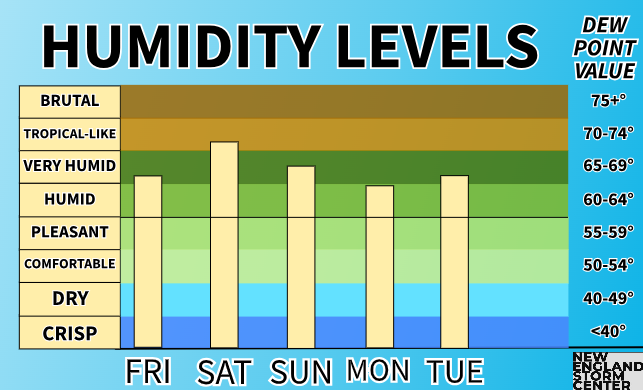
Heading into Saturday, humidity levels and the moisture in the atmosphere will remain elevated as the stalled front over New England begins to lift north as a warm front ahead of a system that will pass to the north of the region. This will keep the same basic setup from Friday around, however, forcing will be increased as the system's cold front approaches. This will allow more numerous storms during the day than Friday.
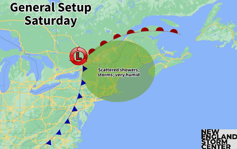
There are discrepancies in the timing of storms for Saturday. Some guidance shows a wave of storms firing up in western New England in the morning before traversing across eastern areas by the early afternoon with another round popping up later in the afternoon. Others are more keen on storms being limited to the afternoon.
The takeaway is that scattered showers and storms will be around throughout the day, but there will be dry times in between. No area is likely to see rainfall all day long. Western and interior northern New England is more likely to see multiple rounds of storms than eastern New England.
HRRR showing potential weather late morning Saturday (1st image) and later in the afternoon (2nd image). This is just one model's interpretation, the takeaway is that there will be scattered storms around throughout the day:


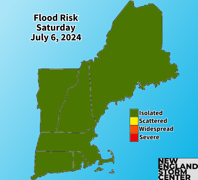
With elevated moisture, the greatest threat will again be torrential downpours. These downpours could lead to isolated flooding issues, especially if areas that get hit with downpours on Friday see more activity on Saturday. The flood threat remains minor and localized overall, with many more areas not seeing issues than areas that do see issues.
The threat for strong severe thunderstorms is currently on the lower end. As of Friday morning, the Storm Prediction Center does not have any part of New England in the threat for severe weather, however, it would not be surprising to see at least western New England get put in the "marginal" (level 1 of 5) threat later today.
This would come as the main ingredients may be able to get in place, with most unstable CAPE values climbing over 1,000 and shear trending upward. Instability will be the big question, but if these trends continue, the severe threat will be raised. With that said, any severe weather Saturday should remain more isolated with more thunderstorms staying below the severe threshold. Strong wind gusts would be the greatest threat in any stronger storm.
Heading into Sunday, the (weakening) cold front associated with the system will cross New England. This front may slow down or stall near the coast, so some lingering showers will be possible Sunday morning. There's a small chance for pop-up showers Sunday afternoon, but, overall, Sunday is looking pretty dry.
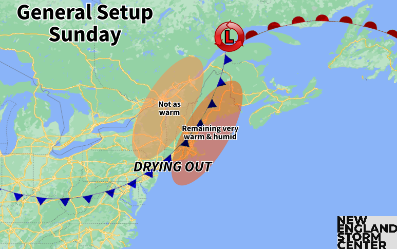
Since this front will become weak, it won't provide a drastic air mass change. Temperatures will remain elevated and humidity will only fall a small amount. July will continue to feel like July. The next frontal system in this parade looks to come around midweek next week.
Comments