Another Unsettled Weekend on Tap for New England
- Tim Dennis
- Apr 4
- 4 min read
New England's next bout of widespread unsettled weather will come this weekend and into early next week. A nearly stationary frontal boundary will be draped across the eastern US from Texas through the Great Lakes for the rest of this week. By Saturday, the boundary will slowly shift eastward as an area of low pressure rises to New England's north. This will likely bring about a widespread, steady precipitation from west to east Saturday afternoon through Saturday night.

The onset time of precipitation on Saturday has trended a bit earlier in the day compared to 24 hours ago. Precipitation will likely move into western New England by late morning and steadily spread east through the afternoon. The system will need to eat away at some dry air over New England when it first arrives. The bulk of this initial wave will begin to end by Saturday evening, however, generally unsettled weather will continue through Saturday night and into Sunday.
Below: RGEM showing potential weather early Saturday afternoon (1st image) and Saturday evening (2nd image):
High temperatures will likely be reached around midday on Saturday. Once precipitation begins to arrive, evaporational cooling will begin to take place. Evaporational cooling is the process of an air mass cooling as water evaporates within it (as water changes from a liquid to vapor, it absorbs heat). Since the precipitation will be arriving in a very dry air mass, initial rainfall will evaporate, allowing temperatures to cool through the afternoon and evening. This will set up a very raw afternoon with a chilly rain for most.
Across the northern tier, enough cooling will likely take place that precipitation will quickly become a wintry mix or snowfall. This is most likely across northern New Hampshire and interior Maine. At this point, only an inch or two of snow is expected across the northern tier, mostly over Maine. Some icing will once again be likely as a warm nose pushes northward with cold air locked at the surface (the theme of this spring so far). Potential icing across the north will be the main thing to watch within trends. There is a high likelihood of at least a tenth of an inch and decent probabilities for up to 0.25”.
Below: Current probability of at least a glaze of ice from Saturday through Sunday morning:

This does generally appear to be another case of initial snow across the north as evaporational cooling takes hold. As a warm front slowly approaches from the south a warm nose of air aloft will push into New England from south to north, changing any snow to sleet and/or freezing rain followed by a change to all rain through Sunday morning. Southern New England and the lower elevations of northern New England will likely remain just mild enough to be all rain.
Saturday night into Sunday, a warm front will continue to lift toward New England, likely reaching southern New England by morning. By Sunday morning, a triple point low (low pressure where a warm, cold and occluded front meet) will likely have formed and will be pushing straight through New England.

This will lead to continued showers through Sunday morning. Showers will likely diminish in coverage as the day goes on; the afternoon could end up mainly dry for a majority of New England with only some spot showers hanging around for the afternoon. There is a chance some sun may be able to poke out in the afternoon, but this is far from a guarantee.
Below: Potential weather Sunday morning (1st image) and Sunday afternoon (2nd image):
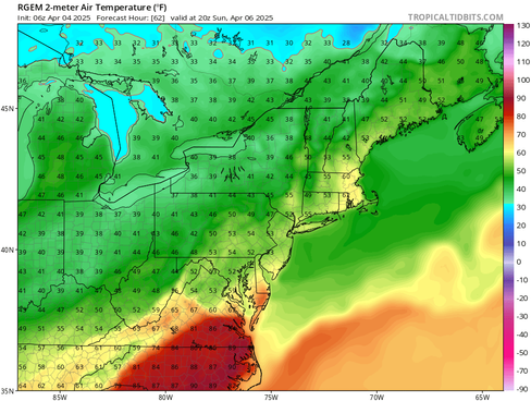
As stated before, temperatures will be cool and raw on Saturday with bouts of rain. As the warm front advances north, temperatures will warm Saturday night through Sunday. The northward extent of the warm sector is a big question mark as the trailing cold/occluded front won't be far behind the advancing warm front. Currently, chances for at least 60° temperatures in southern New England top out at 40%.
The northward advancement of the warm sector remains a point of contention among guidance. With this uncertainty, big swings in the temperature forecast remain possible for Sunday. Regardless of how far north the sector gets, it will be warmer compared to Saturday's very raw feel.
Below: Potential Sunday afternoon temperatures shown by RGEM (1st image, favoring a farther north warm sector and warmer temperatures) and the new Euro's AI model (2nd image, favoring a farther south warm sector and cooler temperatures):
Looking at the big picture, a trough will be digging into the central United States with waves of energy. An elongated frontal boundary is stretched across the Ohio, Tennessee and Ohio Valleys into the northeast. A large ridge over the southeast will prevent the timely eastward progress of this boundary through the weekend. All of this will lead to continued changeable temperatures and sharp temperature gradients across New England in the first week of April.

This will also keep an active pattern around with plenty of chances for precipitation over the next week. With large temperature gradients, a variety of precipitation types continues to be likely across New England. After this weekend, the next system will likely approach in the Monday night to Tuesday time frame, bringing the potential for wintry precipitation across the north as a moisture-starved northern stream system potentially does some phasing with an offshore southern stream system.
Below: Current weather map for Tuesday (April 8):

Looking beyond, the overall pattern does look to flip from where it has been for the first week of April. This will lead to a ridge-in-the-west-trough-in-the-east pattern. This will promote generally cooler weather continuing for the first half of April. This could also promote a continuation of more unsettled weather.


Comments