After high pressure slides across New England today, an Alberta Clipper system will quickly race through New England. This system is pretty robust for an Alberta Clipper, though the heaviest snow amounts will generally remain in upstate New York.
So, what is an Alberta Clipper? It's a low pressure system that typically forms near the Canadian Province of Alberta. The system then rides a usually zonal flow (flat jet stream) in an east-southeast direction across the northern tier of the United States and, in this case, passes right through New England and into the Gulf of Maine.

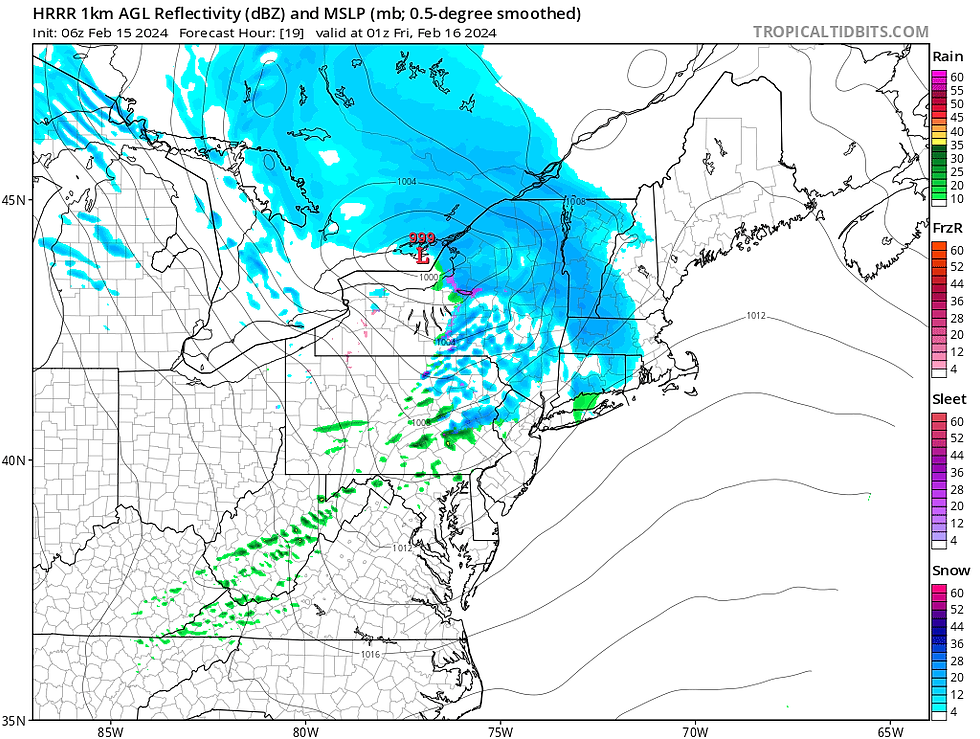
Snow will move into Vermont and western Massachusetts well after dark, likely in the late evening. The snow will travel steadily from west to east throughout the night, resulting in varying snowfall rates. These systems typically produce the most snow on the northwest side of the system. With the storm's trajectory above, this would be northern Vermont, northern New Hampshire and western Maine. Despite this, forcing will allow for snow for several hours across southern New England in the evening through the early morning hours.
Expected weather around 8pm this evening:
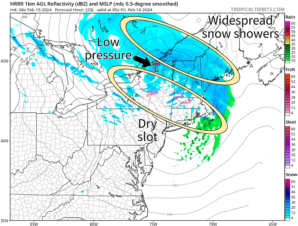
By about midnight and into the early morning hours, snow will be falling across much of northern New England, however, southern New England will likely get into a dry slot on the south side of the system. At this point, southern New England will be reduced to light and scattered snow snow showers.
Expected weather around midnight tonight:
As the system races away early Friday morning, most of the snow will clear out by sunrise. There will likely be lingering snow showers across the mountains, as well as central Maine, through the morning hours. With the most snow growth on the northern side, with 3-5 inches of snow will be possible across northern New Hampshire and western Maine.
The Green Mountains will see the best forcing, leading to amounts up to 5 inches there as well. There could be some higher amounts in the northern Green Mountains. Lesser amounts will be seen as you head further south and the southern dry slot becomes more apparent. Some ocean-enhancement may occur along parts of the Maine coast, boosting numbers there as well. This will be a light and fluffy snow, which does pile up faster.
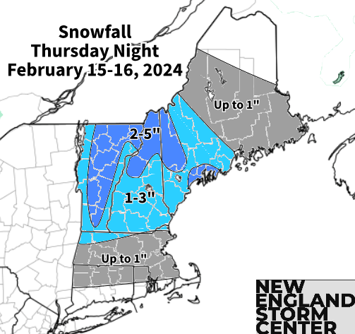
With varying snowfall rates, snow accumulations will likely not be uniform, with some areas seeing more while others will see less. There will be a brief period where up to an inch an hour snowfall rates will be possible across the Green and White Mountains. Winter weather advisories are in effect for much of Vermont, northern New Hampshire and western Maine minus York County.
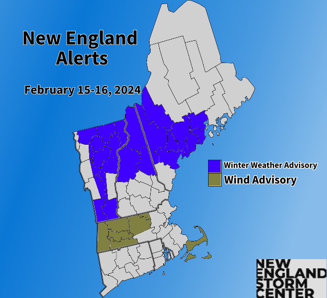
As for the strong wind threat, there will be a 60-70mph low-level jet over southern New England. Signals show that this will be well mixed to the surface. This will support gusts over 50mph with the potential for isolated gusts up to 60mph, mainly across western Massachusetts and northern Connecticut. The threat for these higher winds will not last long, likely only a few hours during the overnight. Wind advisories have been posted for this threat.
wind speed and barbs at 850mb (just under 5,000 feet above sea level):

All of this will be gone by mid-morning on Friday, although the gusty winds will stick around all day for all of New England. Friday will likely be similar to this past Wednesday. Heading into this weekend, a storm system will pass well south of New England and may spread another round of light snow showers into southern New England on Saturday.
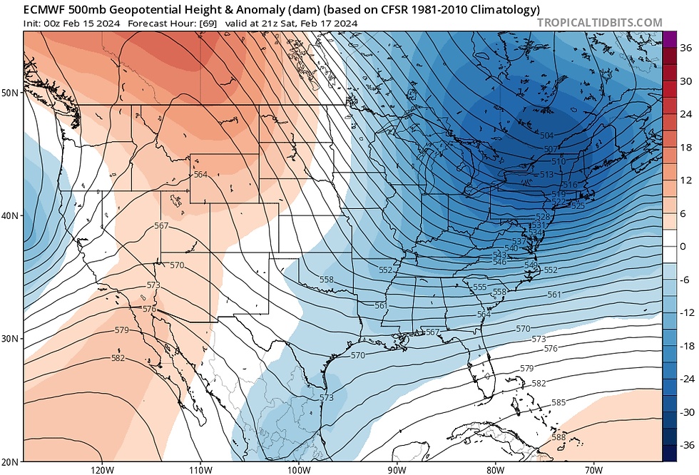
The weekend will be on the colder side (but certainly not arctic) as a large mid-level ridge continues in the west while New England remains under troughing. This will keep New England under cyclonic flow, allowing for disturbances to continue to ripple through, leading to isolated to scattered snow showers and lots of clouds on Saturday.
500mb height anomaly showing continued troughing over the northeast with ridging in the west this weekend:
The ridge will likely flatten with flow becoming more zonal heading toward the end of the weekend. This should allow for a gradual warming trend and calm conditions heading into next week. We'll watch a potential system for late next week.
Comments