After Snowy Saturday Morning, Unsettled Weather Continues for Weekend
- Tim Dennis
- 2 days ago
- 4 min read
A cutoff area of low pressure will continue to slowly meander its way northward from the Mid-Atlantic today. Winter weather advisories remain in place across a good chunk of central New England into this afternoon with several inches of snow likely. Heavy snowfall rates were able to develop earlier this morning, with thundersnow reported across central Massachusetts.
Heading into this afternoon, precipitation rates will begin to lighten up. As this happens, dynamic cooling will weaken and snow levels will rise in elevation. This will bring a change from moderate to heavy snowfall to lighter rain showers and eventually drizzle from south to north. By the evening hours, precipitation will be coming to an end, save for patchy drizzle, for southern and central New England. More widespread showers will be possible across Maine with scattered activity across northern New Hampshire.
Below: HRRR showing potential weather early this afternoon (1st image) and this evening (2nd image):

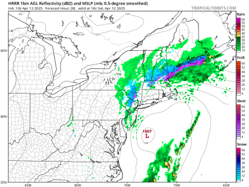


Widespread reports of 3-6 inches of snow have been reported across portions of southern and central New England with a jackpot zone of 6-10 inches in the Worcester Hills. Snowfall rates of well over an inch an hour have been seen with some areas reaching for close to 3 inches an hour earlier in the morning. This came amid strong frontogenesis forcing and dynamic cooling processes, something that was becoming an increasing trend among guidance in the 24 hours leading up to this event.

Moving into Sunday, there remains uncertainty in just how the overall setup will play out. This is due to a secondary low moving up the coast. The big question is just how close to New England's coast the low can track. Naturally, the farther west it moves, the farther inland the precipitation will push. This uncertainty at this range isn't much of a surprise as guidance can struggle mightily with figuring out the movements of a low in a cutoff situation.

There remains a decently large variation among guidance in just how far west the shield of precipitation from this low will spread into New England. There's little doubt showers will be able to push into the coastal plain of New England, with Rhode Island, eastern Massachusetts, southeast New Hampshire and much of Maine seeing precipitation. The system will slowly move northeast before pulling away through the day Sunday.
As stated above, easternmost areas will have the best chance at seeing a period of steady rainfall during the morning hours Sunday. Showers will likely become more and more scattered in nature moving westward. Most guidance has the system moving northeast near Cape Cod before beginning to pull away eastward.
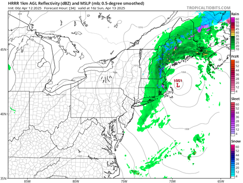
The trusty HRRR, however, has the system moving westward in the Gulf of Maine before pulling eastward, pushing steadier rain into coastal areas and showers much farther west in the region. Whether or not this happens will be something to watch. It should be noted that a farther west track would also lead to a more all-day type rain and a washout scenario across eastern New England rather than just being limited to the morning.
Below: HRRR (1st image) and FV3 (2nd image) showing potential weather Sunday morning. HRRR represents the western outlier while FV3 represents the eastern outlier. Other hi-res models generally land in between these two:


Regardless of how close Sunday's system gets, deep dry looks to enter the region by Sunday night, setting up a very nice day between systems for Monday. The next system will quickly approach Monday night into Tuesday as a frontal system ejects from the Great Lakes and quickly moves over New England with a triple point. This will bring a round of showers (or the potential for more widespread rain in some places).

After the passage of this system, conditions will likely be cooler and blustery behind the cold front. The departing low will likely keep broad cyclonic flow around, allowing for an upslope snow event Tuesday night potentially into Thursday morning for the northern mountains. This will likely bring another fresh round of spring accumulations for some ski resorts still operating (Jay Peak, Killington, Sugarbush and maybe Sugarloaf come to mind). For everyone else, this looks to be a dry period.
New England has been entrenched in a persistent trough over the last few weeks now, leading to a damp start to spring with some ill-timed low pressure systems. A growing question has been when does New England break out of this trough? It looks like the general ridge-in-the-west-trough-in-the-east pattern will hold through next week with no signs of prolonged breaks from precipitation or extended warmth.

After that, however, signs may be pointing toward a gradual eastward shift in the overall pattern heading into late April. That is to say riding and above average heights are poised to slide eastward while more cyclonic flow and troughing enters the west. Overall, the pattern is showing signs of de-amplification, meaning less of a pronounced ridge-trough setup. Exactly how this plays out remains to be seen (mainly in regards to the eastward extent of ridging.

Comments