Active Pattern Continues for New England
- Tim Dennis
- Mar 25
- 4 min read
Yesterday's storm was able to slightly over-perform with its band of snow just north of the rain/snow line. A widespread 4-8" of snow has fallen in a band from central New Hampshire through Maine just inland from the coastal plain. Outside of this banding, much more minimal (or no) snow fell. Southern and central New England grabbed another half inch to inch of rainfall, making another large gain on the drought.

The (weakening) primary low pressure system associated with Monday's system will pass to the north of New England on Tuesday. This will keep the region under broad cyclonic flow, though limited precipitation is expected. This will create plenty of clouds in the afternoon for much of New England. The greatest chance for quick bouts of precipitation will be across the northern tier, closest to the center of the low.
In the summer, this would be a setup for pop-up thunderstorms as there will be steep lapse-rates and some instability this afternoon. Since we're still in the cold months, this will instead create the potential for briefly heavy snow showers across the north. Full-fledged snow squalls are not expected.
Below: HRRR showing potential weather around mid-afternoon today:

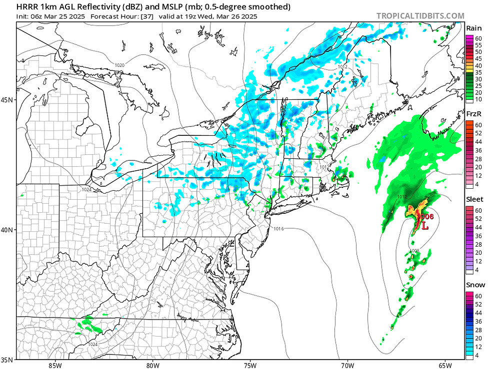
New England will remain in a trough on Wednesday. Another disturbance will rotate through this trough, spawning an area of low pressure to the south of New England. This low will track northeastward up the New England coastline. Recent trends have been pushing this low farther offshore, keeping widespread, steadier precipitation limited to the coastal plain or offshore entirely.

Even without the help of the organized, offshore low, the trough will keep New England under broad cyclonic flow. This will allow for another round of scattered, pop up snow and rain showers throughout New England in the afternoon. They will once again be more likely across northern New England, assuming the coastal low doesn't get close enough to the coast to produce widespread showers over land.
Below: HRRR showing potential weather Wednesday afternoon:

A disturbance will pass to the north of New England Thursday night into Friday. This will drag its associated fronts across the region. This will mainly create a period of gusty winds, however, the air mass won't cool off much behind the cold frontal passage. Friday may end up a notch warmer across southern and central areas versus Thursday as milder air tries to flow in around a high pressure to the south of New England. Another round of scattered precipitation is also expected, but coverage should be lower than Tuesday and Wednesday.

The unsettled conditions show no signs of ending as the next disturbance pushes eastward across the country late this week and into the weekend. There remains a cloud of uncertainty over exactly how this will play out in regards to precipitation types and timing, but an extended period of unsettled weather with multiple waves of precipitation looks likely through the weekend and into early next week.
The root of this unsettled weather will come from a deep trough digging into the Plains this weekend and gradually sliding east. A frontal boundary will extend toward New England from the center of the primary low pressure system. This boundary currently looks to stall to the south of New England through the weekend. Multiple waves of energy may ride along this front, bringing periods of precipitation Saturday and Sunday.

With high pressure to the north of New England and a frontal boundary to our south, it will likely set up a chilly and very raw weekend. Exactly how everything plays out will be determined by the frontal boundary's exact positioning. There is a chance it trends farther north and stalls right over New England. Saturday morning may see the most widespread wintry precipitation across New England before a changeover to rain and a mix for southern and central New England as daytime heating occurs.
Sunday and Monday could see more widespread precipitation, with wintry weather possibly being replaced by plain rainfall from south to north through Monday afternoon as the stalled boundary begins to lift north as a warm front. Sunday and Monday will have the chance to produce a variety of precipitation types over New England from rain to snow to freezing rain to sleet. It's impossible to give any kind of potential range on amounts at this point, so the trends will continue to be watched.
Below: Current probability of impactful winter weather on Sunday:

This overall pattern will keep any kind of springtime warmth just out of reach for New England. This series of frontal passages and troughs will keep the flow around a ridge of high pressure to the south of New England from reaching into the region. Milder temperatures will remain just to New England's west. There is a chance southern New England gets into the warm sector of the storm on Monday, but this is no guarantee and will come with rain.
Below: Temperature departure from average Sunday afternoon:


Comments