A Soggy, Stormy Summer is Drawing to a Close in New England
- Tim Dennis
- Sep 3, 2023
- 5 min read
Just like that (meteorological) summer has drawn to an end. The unofficial closing weekend is here and there remain just two weekends left in astronomical summer. While much of the country baked this summer, some may say New England barely had a summer at all.
To say rain put a damper on things this summer would be an understatement. Concord, New Hampshire saw measurable rain 36 of 92 days from June 1st-August 31st. The longest dry stretch was just 6 days, from June 18-23. Boston and Hartford both saw 38 of the 92 days drop rain. Portland, Maine saw at least a trace of rain on 62% (57 of 92 days) of days this season. Maine bore the brunt of June's unsettled weather.
June began with a cutoff low that literally looped around New England for eight days before finally breaking down. This system caused constant on and off showers, overcast skies and raw days. An unseasonably strong Omega Block lingered for much of the month. This block put New England in a broad trough for the month, which led to nearly constant low pressure over the region. These low pressure systems would get stuck over the region for days on end due to the blocked up pattern.
While June was consistently rainy, it certainly wasn't record breaking. New England has had rainy Junes recently; 2009, 2012 and 2019 were similarly wet. What was different about 2023 is that the rain and clouds were basically constant throughout the entire month. There were no breaks longer than a few days from the showers and overcast skies. Boston recorded its second cloudiest June on record. It was overcast well over 50% of the time. Boston's average amount of time being overcast in June is just 35%.
By the end of June, all the rain began to take its toll. The last weekend in June, over a half foot of rain fell on some communities, including Alexandria, New Hampshire and Andover, Maine. Significant road damage and rescues occurred in both of these towns. Flash flooding continued to occur after this weekend, with flash flood warnings and road washouts reported on Monday and Tuesday following that weekend.

While July would prove to be a much warmer month than June with more sunshine, the flooding rains only intensified. On Independence day, slow moving thunderstorms caused a significant flash flooding event in both downtown Hartford and downtown Providence. These storms added to the nearly half foot of rain the area saw over that holiday weekend. A flash flood warning stated:
"Trained weather spotters reported thunderstorms producing heavy rain. There is significant flooding in the Hartford metropolitan area right now. Several cars are stuck in flooding on Scarborough street and the road is being closed due to the flooding. There are also other streets where cars are are stuck in street flooding in the Hartford area. Between 3 and 6 inches of rain have fallen in the last 48 hours."
A week later, a true flooding disaster unfolded as parts of Vermont were hit with over 9 inches of rain in 24 hours. This caused some of the worst flooding ever in the state, with many residents saying this flood was as bad or worse than the devastating 2011 floods caused by Tropical Storm Irene. An extremely rare flash flood emergency was issued for Weston, Ludlow, Andover and Bridgewater, Vermont.
These alerts are issued for "exceedingly rare situations when extremely heavy rain is leading to a severe threat to human life and catastrophic damage from a flash flood is happening or will happen soon." Of course, everything described in the previous sentence occurred across the state on July 10th and 11th. Recovery from this flood is ongoing and will be ongoing for a long time.
The rains didn't stop after Vermont's great flood. Just two days after this flooding, on July 13th, a severe thunderstorm outbreak loomed over New England. This outbreak spawned a tornado in Vermont and created more flash flooding. The following Sunday, July 16th, New England was facing yet another threat of major flash flooding.
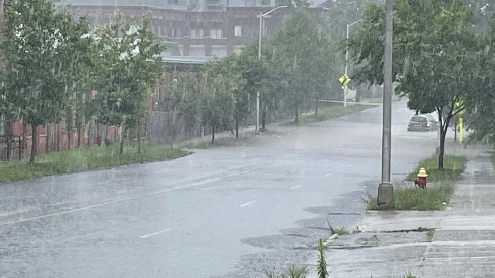
1 to 3 inches of rain fell that Sunday, with some communities seeing upwards of 6 inches once again. Pockets of significant flooding and road damage occurred in Connecticut, Rhode Island, Massachusetts and New Hampshire. Scenes of swamped roads, businesses and stranded motorists were once again common across the region. Alton, New Hampshire was hit particularly hard by this event, with "most" roads in the town damaged. A state trooper called the town an island.
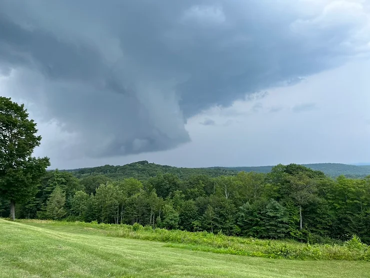
After a brief respite, a severe thunderstorm outbreak occurred on July 27th, bringing the region more stormy weather. This outbreak brought more wind damage than flooding, but widespread flash flooding did occur in the White Mountains. This outbreak also spawned a tornado that tracked through southwest New Hampshire for just over 13 miles, an impressively long track by New England standards.
After a one day break, the month of July closed out with another severe weather outbreak on July 29th. This outbreak brought more tornado warnings, wind damage and flooding. Flash flooding hit parts of Boston hard during this event.
In the end, July proved to be very wet, despite more sunny, summer-like weather in between the storms. Very wet may be an understatement. The National Weather Service office in Gray, Maine issued a record breaking 38 flash flood warnings for New Hampshire alone in July. This not only shatters the old monthly record of 17, but actually surpasses the most warnings issued in an entire year, which was 36.
A collection of photos from across New England taken in July 2023:
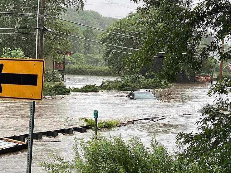
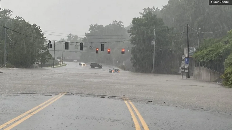


From top left: Flooding in Hartford on July 4 (NBC Connecticut); car submerged in Vermont on July 11; Hartford flooding on July 16 (Lillian Stone); Severe thunderstorm in New Hampshire on July 27 (Matt Hoenig); Ludlow, Vermont on July 11 (Magic Mountain Ski Area); Severe thunderstorm in Hatfield, Massachusetts on July 27 (Ben Cohen).
The weather did start to calm down in August across New England. Despite this, there were issues. On August 8th, severe storms rolled through the region once again. These storms spawned three tornadoes as well as dropped a half foot of rain once again in places. Andover, Massachusetts was hit particularly hard by flooding on this day.
In North Andover, a senior housing center was forced to evacuate 150 residents when the center became flooded. Several businesses sustained heavy damage during the flash floods. Multiple store fronts were seen being boarded up after the waters receded. Nearby Lawrence saw multiple cars submerged on roadways. 6.24 inches of rain was reported in Lawrence.
Ten days later, on August 18th, a severe weather outbreak caused another round of flash flooding. At one point that evening, the entirety of eastern Massachusetts was under a flash flood warning. This outbreak also spawned five tornadoes, including the strongest tornado to tear through New England in nearly a decade. This tornado tracked over 9 miles (another long track for New England) and caused significant damage in Rhode Island.


From left to right: Damage in Rhode Island from August 18 tornado (WCVB); North Andover flooding and damage (X: @MartyMcFLYS)
In the end, rainfall amounts across New England were highly varied. Many of the storms weren't large, soaking rains but rather small, scattered torrential downpours. Because of this, summer 2023 did not break rainfall records in major cities. Boston and Worcester did finish with the second wettest summer on record. Hartford and Portland broke into the top 10 wettest. Places like Providence and Concord just missed their top 10's.
One place that shattered their rainfall record was the summit of Mt. Washington. Just over 4 feet of rain fell on the mountain in the last three months. The nearby town of Jackson, New Hampshire saw 31 inches.
Comments