Tropical Storm Lee, a Cape Verde cyclone, has officially formed as it continues its west-northwest journey across the Atlantic Ocean. With a hot ocean and low wind shear, the storm has little in its way to strengthening over the course of the next week.
So, what exactly is a Cape Verde hurricane? It's pretty simple. It's a tropical cyclone that forms at a low latitude from a tropical wave that exited Africa and passed near the Cape Verde (or Cabo Verde) Islands. These hurricanes rarely strike the United States.
As of now, the storm is expected to reach major hurricane (category 3+) by Friday, with continued strengthening into the weekend. A handful of models have the storm going up to category four or five strength by early next week. There is a very high degree of confidence this far out that Lee will become a powerhouse of a hurricane.
The hurricane is looking to continue in a general west-northwest direction toward the Leeward Islands and Florida. Puerto Rico, Haiti and the Dominican Republic are precariously close to Lee's path. Right now, the storm is expected to move to the north of these nations, but this could change, so these nations will need to closely monitor the storm.

As per usual with Cape Verde hurricanes, Lee will then likely turn to the north, paralleling the United States East Coast. This is thanks to what's called the "Azores-Bermuda High". This semi-permanent ridge of high pressure acts as a major steering tool for Cape Verde hurricanes. The high acts as sort of a barrier that hurricanes can't go through, so they are forced to "drive" around it.

How close (or how far) hurricanes get to the east coast with this type of hurricane is dependent on other factors, such as the set up of the jet stream over the United States. In Lee's case, which will make its pass at the east coast next week, a dip in the jet stream will likely help keep the hurricane from making landfall.
This dip in the jet stream acts similar to the ridge of high pressure mentioned above. It acts as another steering tool. The hurricane will "hit" the trough (which is essentially the jet stream dip) and be forced to the north, unable to break through it.
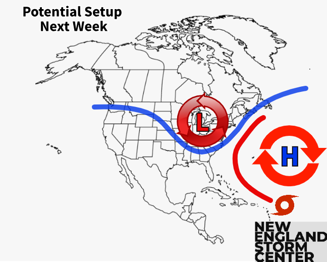
The above graphic says potential since this is looking a week plus into the future. As everyone knows, forecasts can (and do, and always will) change. While a trough over the eastern United States is very likely to occur, its exact position will play a major role in how close the storm gets to the coast.
Depending on where the trough sets up, it will help keep the storm at bay or it could help pull the storm in closer. The timing of the trough is also important. Right now, the trough is looking to move eastward in time to kick Lee away from the coast. If this timing slows down, and the trough takes longer to arrive in the east, Lee will have a window to get closer.
The strength and exact position of the ridge of high pressure will also play a role. While the ridge will be there, its exact strength and size will be important on how it steers the hurricane.
While most hurricanes in Lee's position turn north and parallel the east coast, there are exceptions. In 2018, Hurricane Florence didn't take the turn north as expected and barreled into the Carolinas, causing one of the most extreme rain events in recent history.
Again, being more than a week out, there are many options on the table. Most models have the hurricane remaining offshore of the United States, which is currently the most likely outcome, but we'll just need to keep watching to see how everything sets up, which won't become clear until later this week.
Current spaghetti models for Lee, showing the storm curving to the north:

Here's what a few major models are currently showing:


As you can see, timing and position are still up in the air.
Comments