After Tuesday morning's rain, New England's next system will begin to move into western New England toward Wednesday evening. This system will involve a trough of low pressure racing from the Tennessee Valley through the northeast within 24 hours. A northern stream system will scoot from the Great Lakes to the north of New England during this time. This system looks to be more on the minor side with mainly rain in southern New England and along the northern New England coastal plain with snow across the interior.

With minimal blocking in place, this will be a quick hitter. The main storm system will dart from around Kentucky Wednesday morning to around Nova Scotia by Thursday morning, making this a short duration storm for New England. Precipitation is expected to break out Wednesday evening across western New England and steadily push east through the first part of Wednesday night. Initial precipitation may be rain or a mix for most in the evening before transitioning to snow from north to south and high elevations to lower elevations.
Below: CMC showing potential weather Wednesday evening:

By Wednesday night, a steady snow will likely be falling across much of interior northern New England with rain elsewhere. The storm will wrap up as quickly as it started, shutting down from west to east through Thursday morning. By midday, only scattered upslope snow showers will likely remain.
Below: CMC showing potential weather late Wednesday night:

The quick-moving nature of the storm combined with the fact that it won't get all that strong will preclude a major snowfall (or rainfall) event for New England. Tuesday's cold front will provide slightly colder air, but temperatures will be marginal across the region. The storm still appears poised to track near Cape Cod. This track inside the benchmark will favor more by way of rain across much of southern New England, snow across much of northern New England and a mix zone in between.
Through Wednesday night, the temperature will drop and precipitation rates will increase, allowing the rain/snow line to inch southward. How far south the rain/snow line gets will be determined by the storm's final track. The farther south the storm tracks, the farther south the rain/snow line will get pulled. The main question on this front is how close to the coast the sow can make it to the northern New England coast. The southern New England coastal plain will be all rain the entire time.

As stated before, this will likely be a minor system, with minimal snowfall and rainfall amounts. Much of interior northern New England stands to pick up 2-5 inches of snow, with the most across higher elevations. Amounts will drop off heading lower in elevation and to the coast. Whether mixing or snow makes it all the way to the coast will be rather inconsequential as amounts there will be very low either way. With marginal temperatures, this will be a heavier, wetter snow with ratios under 10:1 for most.

After this system, an Alberta Clipper will swing down from the Great Lakes later on Friday. At the same time, a coastal storm well offshore will be moving northeastward. The question remains as to how much these two features will interact, and when they'll interact. The answer to this question will determine what kind of impacts occur in New England and where.

Should the clipper system and coastal system stay separated, it would likely bring some scattered snow showers to parts of New England later Friday into Saturday morning. Should interaction or phasing occur between the systems, it could lead to a more complex system with heavier precipitation rates. More interaction would also likely lead to warmer air being drawn in and a rain/snow line setting up near the coast.
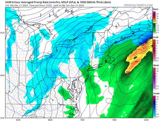
As has been the case for the last couple days, most guidance is keen on the systems remaining separated, leading to a low-impact event where much of New England could see scattered, light snow showers as the clipper weakens. With that said, the coastal storm is close enough that trends still need to be monitored. As of now, this could be a decent snowstorm for Atlantic Canada/Nova Scotia as it all comes together just beyond New England.
Below: Model roundup (Euro, GFS, CMC, GraphCast) for early Saturday morning. These model runs are from Tuesday morning:
Regardless of how the precipitation plays out this weekend, it will swing the door wide open for an arctic air mass to enter the region. This air mass looks to settle over New England on Sunday, when high temperatures will likely range from the single digits across the cold hollows of northern New England to low 20s in southern New England. Wind chills will likely be sub-zero for most of New England Sunday morning and lows will be around zero region-wide.
Below: Temperatures aloft Sunday morning showing the Arctic air mass wrapping around the backside of the storm system:

Temperatures are currently looking to begin to moderate by Christmas Eve, with more seasonable temperatures for the holiday. At this point, there are no signals for any large-scale storminess heading into Christmas. A ridge-in-the-west-trough-in-the-east pattern may begin to break down heading into Christmas week, which could potentially support calmer and more mild conditions. Only time will tell exactly how this pans out.


Comments