A Change in Pace is Coming for New England's Weather
- Tim Dennis
- Jun 12, 2024
- 3 min read

New England's weather has been very stagnant over the past week or so now as an upper-level low has sat to the north and west of the region. This has led to each day being pretty much the same as the last with increasing afternoon clouds and scattered showers cropping up, mainly in northern New England. Wednesday will be the last day in this pattern before a change in pace. A major change in pace will be coming next week in the form of full on summer heat.
A warm-up initiates today, but will really be felt starting on Thursday. Wednesday will once again see scattered showers and potentially a thunderstorm or two crop up in the afternoon. While a shower is possible anywhere in New England, they will be most likely across New Hampshire and Maine. Any shower that develops will be rather slow moving and capable of producing downpours.
GFS showing potential weather around mid-afternoon Wednesday:

Thursday will finally see New England shake the influence of the upper-level low. A southwest flow develops ahead of another approaching trough. This will bring a much warmer air mass into the region and send temperatures into the 80s for just about everyone. Despite the southwest flow, low dew points are expected to mix down to the surface, keeping humidity in check, so it won't be a humid heat.
On Friday, an area of low pressure will pass to New England's north, dragging a cold front across the region. Ahead of the front will see a surge of more moist, humid air for Friday. This is a classic setup for a summer thunderstorm day. A line of storms will likely break out ahead of the front as it passes throughout the day from northwest to southeast.
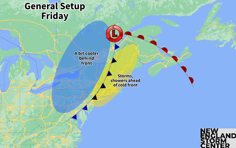
As far as the nature of the storms, the four main ingredients will be in place for severe weather for at least part of New England. Shear, lift and moisture will be firmly in place with the cold front providing lift and a surge of humidity ahead of the front providing moisture. As usual in this setup, the amount of instability will be the main question mark. Lapse rates (basically the decrease in temperature with altitude) are looking to be rather steep, which does indicate a more unstable environment.
The key to the extent of severe weather and where stronger storms would most likely be will hinge on the cold front's timing. Areas that see the front slide through later in the day with storms firing in the afternoon will see the most instability and therefore the highest potential for stronger storms. A trend toward a later arrival would push the severe threat north while a quicker trend would lower the threat for all of New England.
NAM showing the line of storms heading into Friday afternoon. This exact timing is not locked in:

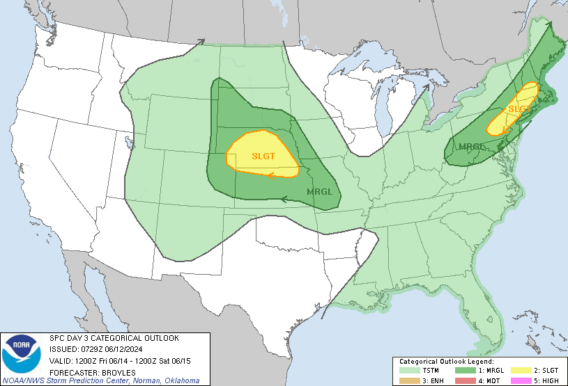
The Storm Prediction Center currently has much of Massachusetts, northern Connecticut and southern New Hampshire highlighted in the "slight" category (level 2 of 5) for the risk of severe storms. Again, based on the trends, this threat could decrease over the next 24-36 hours.
Storm Prediction Center thunderstorm risk for Friday:
This cold front will set up about as perfect of a weekend as there can be in mid-June. Highs will be in the 70s for most with some low 80s and the mountains holding to the 60s on Saturday. High pressure builds from the northwest, bringing a mainly sunny sky and very low dew points.
Next week continues to look likely to feature full-on summer heat and humidity. Signals have been pretty consistent showing a trough-in-the-west-ridge-in-the-east pattern developing. This will come with an expansive area of high pressure in the east, which may set up a heat dome. The position of this high will help determine the level of heat that will get into New England as well as the extent of any potential afternoon storms/showers. New England will likely be more on the edge of the ridge of high pressure.
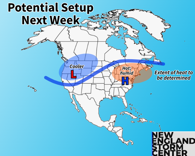
Since this is looking a week plus out, any sort of details on how hot and what the hottest days will be next week remain to be determined as small scale factors have to come into view. These small-scale factors (unsettled weather rounding the edge of the ridge, a backdoor cold front creating a cooler easterly flow for eastern areas) could serve as spoilers to the heat.
This sort of setup is supportive of the first heat wave of the season in portions of New England (the Connecticut River Valley, Merrimack Valley and Champlain Valley come to mind). Again, whether this happens will be determined by the smaller-scale factors that still need to come into view.
Comments